Landsat 8 Image Confirms Mount Michael's Persistent Lava Lake
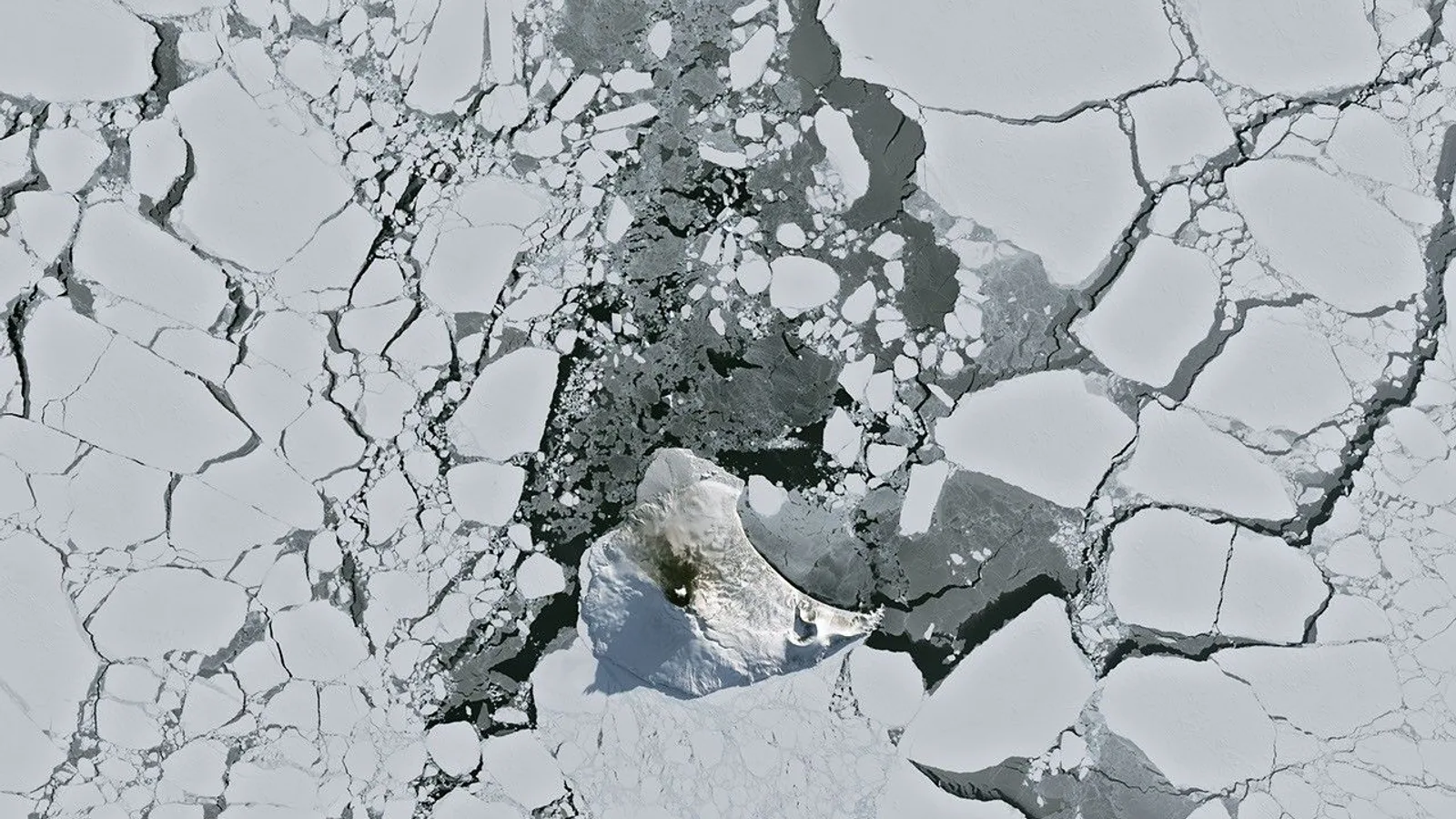
An unusually clear satellite pass over the sub-Antarctic South Atlantic has put fresh evidence behind a finding scientists cannot gather on the ground: Mount Michael, the stratovolcano at the centre of Saunders Island, holds a persistent lava lake in its summit crater.
The Operational Land Imager aboard the NASA-USGS Landsat 8 satellite acquired the image on August 24, 2026, as austral winter cloud cover briefly lifted. NASA's Earth Observatory, which published the frame as its Image of the Day on September 7, 2026, overlaid the natural-colour scene with an infrared signal from OLI bands 7-6-5, shown in red, revealing heat from the lava lake. A puff of volcanic plume above the peak and darkened snow on the northern slopes also suggest ongoing activity, the Earth Observatory said.
The lava lake itself is not a new discovery. NASA's Landsat programme credits the identification to a 2019 study in the Journal of Volcanology and Geothermal Research, led by Danielle Gray of University College London with Alex Burton-Johnson of the British Antarctic Survey, which made Mount Michael the eighth volcano worldwide confirmed to host a persistent lava lake. The two NASA pages describe different evidence windows: the Earth Observatory cites an analysis of thermal anomalies in Landsat, Sentinel and ASTER observations spanning 30 years, while the Landsat programme page says the 2019 team worked from imagery covering 2003 to 2018.
Why it matters: only a handful of volcanoes on Earth are known to sustain such a feature. NASA's Earth Observatory names Kīlauea in Hawaii, Nyamulagira in the Democratic Republic of the Congo and Erta Ale in Ethiopia. Saunders Island belongs to the South Sandwich Islands, a string of small volcanic peaks about 350 kilometres (220 miles) long that formed where the South American plate subducts beneath the tiny South Sandwich plate. Because the islands are so remote and so often clouded over, researchers depend on satellites rather than ground instruments to read what the volcano is doing — which is why a single clear frame is worth publishing at all.
What remains open is how energetic the lake currently is. Thermal readings from the MODIS and VIIRS instruments, delivered through the MIROVA near-real-time hot spot system, indicate only low-intensity activity over the past several years, according to the Earth Observatory, and NASA's Aura satellite shows that emissions of sulfur dioxide and other gases are common at the volcano. When Landsat 9 passed over on September 1, 2026, cloud had returned; the 843-metre (2,766-foot) peak bent the wind into a train of V-shaped wave clouds downstream, and false-colour imagery from NASA's Aqua satellite indicated a track likely tied to volcanic sulfur dioxide. Further clear passes remain the only realistic way to keep watching.
Sources
Related
Dinosaur Dung Preserves First Known Feathers of a Diving Bird
2,884 Supernovae Favour Changing Dark Energy at 3.3 Sigma
Chandra Archive Yields 84 'Hypersoft' X-Ray Sources in 6 Galaxies
Manhattan-Size Iceberg Survives Greenland Crash
World's Biggest Dark Matter Detector Spots Mystery Particle
New Simulations: Moon May Have Formed in Just 5 Hours
Dark matter hunt sees one puzzling particle — not proof yet
Fusion Reactor 'Flaw' Found to Suppress Turbulence
Trending now
- Fake IT Helpdesk Calls Defeat Passkey Logins, Microsoft Says
- Zverev Beats Shelton in 4 Sets for First US Open Title
- VW Mission Efficiency Sets 0.158 Cd World Record
- Marvel's Wolverine Lands on PS5 With a 77 Metascore
- Revolut Breach: Attackers Demanded 10,000 Bitcoin Ransom
- Saudi Pipeline Repairs to Take Weeks as Brent Tops $107
- US Diesel Sets Record $6.23 a Gallon, AAA Figures Show
- Sogou Flaw Let One Click Backdoor an App Used by 455M a Month
Comments
No comments yet. Be the first.